Logistics at a Glance
| Item | Details |
|---|
| Entry fee | $35/vehicle (7-day) — America the Beautiful Pass accepted |
| Timed-entry reservation | Required for peak season (typically May–September, sometimes beyond). Check recreation.gov for current windows. Sell out within minutes of release. |
| Half Dome permit | Lottery via recreation.gov; pre-season lottery in February/March; day-before lottery available some dates. $10/person permit. Cables are up approximately late May through mid-October. |
| Camping reservations | Open 6 months to the day in advance at recreation.gov. Valley campgrounds (4 Mile, Camp 4, Housekeeping, North Pines, Lower Pines, Upper Pines) book within seconds at 7am Pacific. Set an alarm. Have multiple tabs ready. |
| Walk-up sites | Camp 4 holds a small number of walk-up sites per morning (first-come, available at kiosk). Arrive by 7am or earlier in peak season. |
| Wilderness permit | Required for overnight backpacking. Half of permits released 60 days in advance online; half walk-up day-before. |
| Cell coverage | Very limited in the valley and non-existent in most high country. Download all maps offline before entry. |
| Nearest hospital | Yosemite Medical Clinic (Valley, seasonal), Doctors Medical Center in Modesto (2 hours), UCSF Medical Center in the Valley has emergency services. |
Day-by-Day Schedule
Day 1: Valley Floor Orientation
Arrive early. If driving from the Bay Area or LA, plan arrival before 10am.
After Check-In — Valley Loop Trail
The Valley Loop is 13 miles of mostly flat trail connecting all the major valley floor viewpoints. Do a partial loop — pick up any section from Yosemite Village, Curry Village, or Yosemite Falls trailhead.
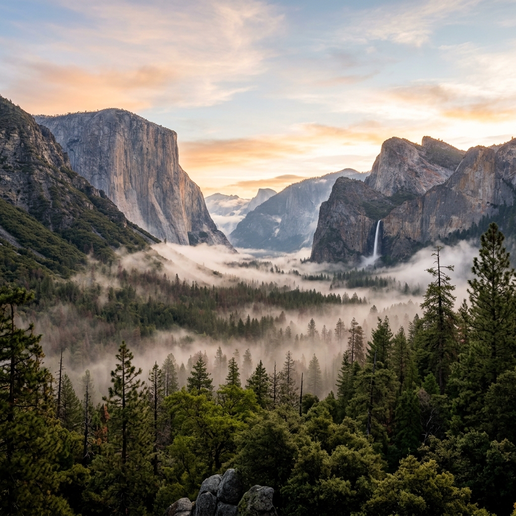
Valley View (roadside pullout on Valley entrance road): The first iconic view — El Capitan right, Cathedral Spires center, Bridalveil Fall left. Take this photo.
Yosemite Falls Trail
- 7.6 miles round trip to the top; shorter options available
- Lower Yosemite Falls: 1 mile RT — accessible, impressive especially in spring
- Upper Falls: Add 3.1 miles each way and 2,700 ft elevation gain
- Best flows: April–June
Bridalveil Fall
- 0.5 mile RT from parking area
- Gets mist on visitors (bring a rain jacket in spring)
- Best flows: April–June
Evening: Cook at camp or eat in Yosemite Village. Curry Village has limited food options. The Ahwahnee Dining Room requires reservations and appropriate attire.
Day 2: Half Dome (Permit Required) or Panorama Trail
If you have a Half Dome permit:
- Start: 4am from Happy Isles trailhead (or previous night's camp at Little Yosemite Valley for backpackers)
- Distance: 16.4 miles round trip, 4,800 ft elevation gain
- The sub-dome stairs: Steep but straightforward
- The cables: The final 400 ft at approximately 45–60° gradient. Gloves required — provided by NPS at base or bring your own (cable hooks are wood-slat steps with two chain cables as handrails). This is not technical climbing but it is exposed. Acrophobic visitors should know this before committing.
- Summit at approximately 8,836 ft. Permit required to go beyond the sub-dome.
- Return: Follow same route back to Happy Isles
- Bring: 3+ liters water, headlamp, snacks, sun protection, layers (summit can be 20°F colder than valley)
- Turn back criteria: Lightning visible anywhere in the Sierra. Cables become extremely dangerous when wet. Thunderstorms are common in July/August afternoons.
If no Half Dome permit — Panorama Trail:
8.5 miles point-to-point (take shuttle back from Happy Isles). Trail runs along the south rim with sustained above-valley views of Half Dome, Clouds Rest, and Yosemite Valley. Less busy than the valley floor.
Day 3: Tioga Road / Tuolumne Meadows (if open)
Tioga Road (Highway 120 east) is typically open late May/June through November — check nps.gov/yose for current status.
Drive Tioga Road east — the transition from valley forest to high alpine in 45 minutes is one of the most dramatic drives in the Sierra Nevada.
Tuolumne Meadows (elevation 8,600 ft)
- Open mid-June through October
- The high Sierra's iconic subalpine meadow
- Lembert Dome: 2.8 miles RT from the trailhead near the meadow. A granite dome you hike up (no ropes), with panoramic views of Tuolumne Meadows below. Classic.
- Dog Lake: 2.6 miles RT from Lembert Dome trailhead. Easy high country lake loop.
Olmsted Point (Tioga Road pullout on the west approach):
Stunning exposed granite with views of Half Dome from the back side and Tenaya Lake below.
Tenaya Lake:
Roadside high-altitude lake. Swimming allowed (cold — this is snowmelt). Short walks around the shore.
Return to valley: Allow 1.5 hours driving time.
Day 4: Glacier Point Road + Departure
Glacier Point Road
Typically open late May through November. Drive to Glacier Point for the full valley panorama: Half Dome, Nevada and Vernal Falls, El Capitan — all from 7,214 ft.
Glacier Point to Sentinel Dome: 2.2 miles RT, mostly flat. A bare granite dome with 360° High Sierra views—arguably the single best viewpoint not requiring a Half Dome permit.
Taft Point: 2.2 miles RT from same trailhead as Sentinel Dome (split at the junction). A narrow, unfenced overlook 3,500 ft above the Valley floor. If you are comfortable with exposure, this is genuinely spectacular. Keep children and dogs back from the edge — no railing.
Noon: Depart the park via whichever entrance makes sense for your drive home.
Where to Sleep
| Option | Details |
|---|
| Upper Pines (Valley) | 238 sites; most sites reservable 6 months ahead; close to Half Dome trailhead |
| North Pines (Valley) | 81 sites; slightly less competition than other valley campgrounds |
| Camp 4 (Valley) | 35 sites; walk-up only (some reservable); famous as the rock climber's camp; tents only; close to Yosemite Falls trailhead |
| Tuolumne Meadows Campground | 304 sites; open mid-June through late September; reservation required; dramatically different experience from valley |
| Curry Village tent cabins | Managed accommodations; advance booking required |
| The Ahwahnee | Historic luxury hotel; book 6–12 months ahead |
| Wawona Campground | South entry area; reservable; quieter than valley |
What to Pack (Yosemite-Specific)
- Bear canister or use bear boxes on site — Valley bear boxes are at all campsites; backcountry requires BV500 or approved equivalent
- Gloves for Half Dome cables — cable hooks are wood; bare hands slide and blister
- Layers for Tuolumne — valley temperatures do not predict high country temperatures (can be 25°F colder)
- Sunscreen — granite reflects UV significantly
- Headlamp — essential for early Half Dome start
- Cash — limited ATM access; Curry Village food service is cash-possible but unreliable for card
Common Mistakes at Yosemite
- Arriving without a timed-entry reservation in peak season. You will be turned away at the entry gate. This is enforced.
- Attempting Half Dome without a permit. Rangers check permits at the sub-dome. No permit = no summit.
- Expecting campsite walk-up availability in July and August. The Valley is essentially fully booked most summer nights. Book 6 months to the day.
- Underestimating Half Dome. It is 16.4 miles with 4,800 ft gain. Inexperienced hikers consistently underestimate it. Plan for 10–14 hours.
- Not downloading offline maps. Cell coverage in the Valley and especially Tuolumne/Tioga is unreliable to nonexistent.
Quick-Reference Card
| Item | Info |
|---|
| Park entry (car) | $35/vehicle, 7-day |
| Timed-entry | recreation.gov (in season) |
| Half Dome permit | recreation.gov lottery |
| Camp reservations | 6 months ahead, 7am Pacific |
| Tioga Road status | nps.gov/yose/planyourvisit/tioga.htm |
| Valley Visitor Center | (209) 372-0200 |
| Yosemite Medical Clinic | (209) 372-4637 |
| Emergency | 911 |