Logistics at a Glance
| Item | Details |
|---|
| Entry fee | $35/vehicle (7-day) — America the Beautiful Pass accepted. Note: the coastal strip and Hoh are accessed by different entrance roads; one pass covers the whole park. |
| Wilderness permit | Required for all overnight backpacking. Ozette Triangle: quota enforced; permits available at recreation.gov (reserve ahead in summer) and walk-up at Wilderness Information Center. |
| Coastal hiking tide tables | Critical: Some coastal sections are impassable at high tide and require use of headland trails (overland routes). Download tide tables from tidesandcurrents.noaa.gov and carry a printed copy. |
| Ferry reservation | Bainbridge Island ferry reservations strongly recommended in summer. Book at wsdot.com/ferries. |
| Campgrounds | Kalaloch (coast-adjacent, year-round), Hoh (rainforest), Sol Duc (hot springs), Mora (near Ozette, for Rialto Beach day access). All reservable at recreation.gov. |
| Cell coverage | Essentially none in the rainforest and coastal sections. Download all maps and tide tables offline before leaving cell coverage. |
| Nearest hospital | Olympic Medical Center, Port Angeles (90 min from Hoh Rain Forest, 45 min from Hurricane Ridge) |
Day-by-Day Schedule
Day 1: Hoh Rain Forest
Drive time from Seattle: 3–3.5 hours via ferry + US-101 south.
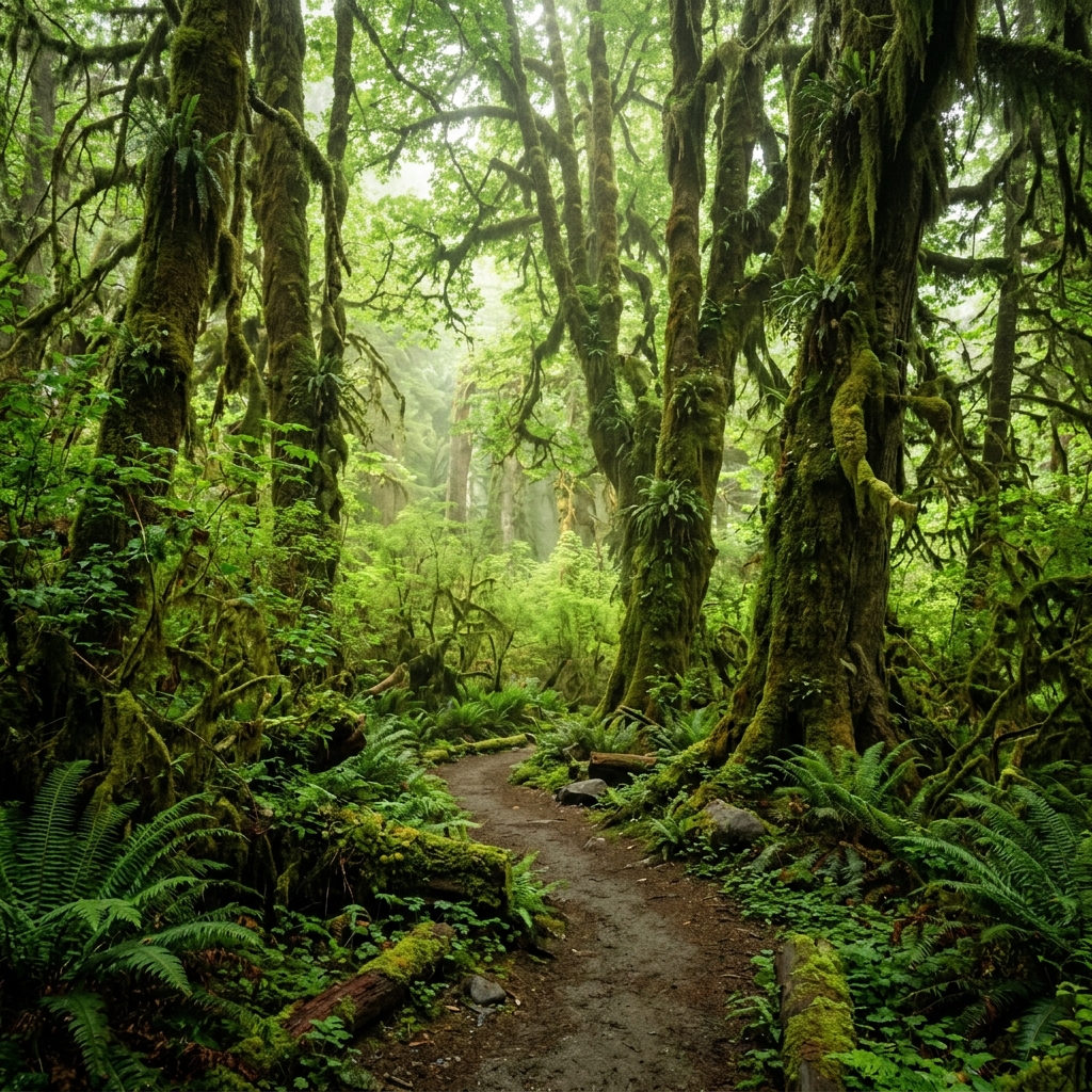
The Hoh Rain Forest is one of the most extraordinary landscapes in North America. Ancient Sitka spruce and bigleaf maple draped in club moss, completely silent forest floor carpeted in ferns, and a level of quiet rarely available in modern life.
Hoh River Trail:
The primary trail through the rainforest. Goes 17.4 miles to the terminus — you don't need to go far.
- Hall of Mosses Trail: 0.8-mile loop; detours from Hoh River Trail near the visitor center. The classic Hoh image — enormous maple trees with curtains of club moss. Do this regardless of everything else. 45 minutes.
- Hoh River Trail to Mineral Creek Falls: 1.8 miles from Hoh Visitor Center; quiet forest walk with a waterfall punctuation.
- Continue up Hoh River Trail: Each mile deeper adds more solitude and unchanged old-growth forest.
Afternoon:
If you want a longer day, continue up the Hoh River Trail to Five Mile Island (5 miles) — a gravel bar on the Hoh River with views of Mt. Olympus's glaciated flanks. The most dramatic Hoh backcountry access without requiring a wilderness permit overnight.
Overnight: Hoh Campground or continue toward the coast.
Day 2: Ozette Triangle (Backpack) or Rialto Beach / Cape Flattery Day Hike
Option A: Ozette Triangle Overnight (Permit Required)
The Ozette Triangle is one of the premier backpacking routes on the Olympic Peninsula.
Route: Ozette Trailhead → Boardwalk trail → Cape Alava → South along beach → Sand Point → Boardwalk trail → Return to Ozette. 9.4-mile loop.
Permit: Required for camping at Cape Alava and Sand Point backcountry camps. Reserve at recreation.gov — summer weekends fill quickly.
Tide planning is mandatory:
The beach section between Cape Alava and Sand Point includes sections impassable at high tide. Download the tide table and plan your beach traverse for a low-to-incoming tide window. The overland bypass adds 0.5 miles.
Key features:
- Sea stacks: Iconic offshore rock formations along the coastal section
- Cape Alava: The westernmost point of the contiguous United States
- Tidepools: At low tide, extraordinary intertidal ecosystems — sea anemones, starfish (though sea star wasting disease has reduced numbers), urchins
- Ancient whale bones and petroglyphs near Cape Alava — look for Makah Tribe cultural site markers; these are significant — do not disturb
Carrying water on the coast:
Fresh water sources on the coastal section require filtering (creeks cross the beach at multiple points). The Sawyer Squeeze is ideal here.
Option B: Rialto Beach Day Hike (No Permit)
If you didn't get an Ozette permit or prefer a day trip:
- Rialto Beach: Drive to the coast near Mora Campground. The beach itself starts from the parking area.
- Hole-in-the-Wall: 1.5 miles north from the Rialto parking area along the beach. A sea arch eroded through a headland — only accessible during lower tides. Check tide tables.
- James Island: Visible from the beach; significant Quileute tribal cultural landmark — respect sight lines and boundaries.
Important: The 1.5-mile beach walk to Hole-in-the-Wall passes Ellen Creek, which may have high crossing in wet season, and requires navigating a headland at high tide. Always check tide table.
Day 3: Hurricane Ridge (Alpine) + Departure
Hurricane Ridge is the park's primary alpine access — 17 miles from Port Angeles at 5,242 ft.
Hurricane Ridge Visitor Center:
Panoramic views of the Olympic Mountains. Open year-round weekends; daily in summer.
Trails at Hurricane Ridge:
- Hurricane Hill Trail: 3.2 miles round trip from the end of the road. Meadows, wildflowers in summer, panoramic Olympic Mountain views. Moderate.
- High Ridge Interpretive Loop: 1.5 miles, paved/unpaved. Subalpine meadows accessible to most visitors.
- Deer Park Road (seasonal, late June–September): A rougher road to a higher and more isolated access point — fewer crowds, even more dramatic views.
Olympic Marmots: The endemic, endangered Olympic marmot lives only on the Olympic Peninsula. Hurricane Ridge is the best place to see them (look for large, tan ground squirrel-like mammals on rocky slopes, July–September).
Afternoon: Depart via Port Angeles. Consider stopping at the Port Angeles waterfront before catching the ferry or driving home.
Where to Sleep
| Option | Details |
|---|
| Hoh Campground | 78 sites; year-round; reservation required in summer; no hookups; flush toilets |
| Kalaloch Campground | 170 sites; on coastal bluff; year-round; ocean sounds; reservation required in summer |
| Mora Campground | 94 sites; near Rialto Beach; reservation required in summer |
| Sol Duc Hot Springs Resort | Campground + resort; hot springs pools (pay to use); reservation required |
| Heart O' the Hills (Port Angeles) | For Hurricane Ridge access; gate access restricted in winter |
| Ozette backcountry camps | Cape Alava and Sand Point; permit required; primitive; pit toilets |
What to Pack (Olympic-Specific)
Rain gear is not optional:
- Full hardshell jacket and rain pants — even in July, the Hoh averages 10+ inches of rain per month. "Water resistant" does not cut it.
- Gaiters for the Hoh River Trail and muddy coastal sections
- Rain cover for your pack
For coastal hiking:
- Tide table (printed or downloaded offline) — do not count on cell service
- Neoprene socks optional but useful for creek crossings
- Trekking poles for stream crossings and mud
For the rainforest:
- Waterproof boots (not trail runners unless fully waterproofed)
- Lightweight camp shoes for drying out at camp
Common Mistakes at Olympic
- Not downloading tide tables before coastal hiking. Some sections require a specific tide window. Missing it means being stuck on the wrong side of a headland or crossing in dangerous surf.
- Underestimating driving distances. The Hoh Rain Forest, Hurricane Ridge, and the coast are each 1.5–3 hours from each other. You cannot visit all three in a day.
- Not having rain gear. The Hoh Rain Forest is wet. The coast is wetter. "It might not rain" is not a viable plan.
- Trying to do the Ozette Triangle without a permit in summer. Walk-up permits often run out by 9am on summer weekends.
- Missing the ferry reservation. Summer Bainbridge Island ferries are fully reserved hours or days in advance. Walking on is usually possible; car reservation is essential if you have a vehicle.
Quick-Reference Card
| Item | Info |
|---|
| Park entry | $35/vehicle, 7-day |
| Wilderness permit | recreation.gov |
| Tide tables | tidesandcurrents.noaa.gov — Station 9443090 (La Push) |
| Bainbridge ferry | wsdot.com/ferries |
| Olympic WIC (permits) | (360) 565-3100 |
| Hurricane Ridge Road status | nps.gov/olym/planyourvisit/hurricane-ridge.htm |
| Olympic Medical Center (ER) | (360) 417-7000 |
| Emergency | 911 |